

MAKERS shared with the UW students how we used tools like QGIS in a professional setting.
Engagement between students of urban planning and working practitioners helps students form a more nuanced view of the professional world they are preparing to join. At the same time, it helps working planners keep up with emerging trends in planning thought. These connections are important to MAKERS as a firm, and for many years we’ve worked with the University of Washington’s College of Built Environments staff and Professionals Council to share the skills and approach we apply to planning.
Although the COVID-19 pandemic disrupted university life and led to the cancellation of in-person events, it remains important for professionals to stay involved with planning students who have continued their studies online. To this end, four MAKERS staff recently shared a two-hour training and information-sharing presentation with the university’s Master of Urban Planning (MUP) students. Presenters walked through the processes and tools that we use day-in and day-out in our work. We shared how we use software tools like CAD, Adobe Illustrator, Photoshop and InDesign, and ArcGIS and QGIS in a professional setting. More importantly, we discussed how we fit these tools into steps of project development: existing conditions analysis, concept mapping, site planning, layout, and rendering the final designs.
Our presenters included:
-

- John Owen

-
- Scott Bonjukian

-
- Ian Crozier

-
- Emily Mozzone

- John Owen, AIA, partner at MAKERS and practicing planner for nearly five decades, shared tips on hand-drawing and reflections on the professional roles that planners play over the course of a career. John emphasized the importance of choosing the right software and analytical tools for each job throughout the planning process.
- Scott Bonjukian, AICP, associate planner/urban designer and 2015 MUP graduate, shared insights on site planning and planning rules of thumb. Scott walked students through a detailed, step-by step approach to develop accurate and legible site plans using GIS, CAD, and Illustrator.
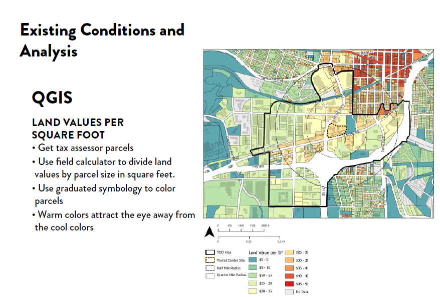
- Ian Crozier, AICP, associate planner and 2017 MUP graduate, compared strengths and weaknesses of industry standard ArcGIS versus open-source QGIS tools and shared examples of different kinds of existing conditions maps developed with these programs for recent projects. Ian also took students inside the mechanics of a working concept map in illustrator to show how overlapping layers and effects can be used in a single well-built Illustrator map to produce many different outputs.
- Emily Mozzone, marketing and office coordinator, shared how her background in marketing and document design led her to her career in the planning industry. She shared tools and strategies to manage large quantities of complex information and advice on how to choose the right software tool for specific needs and how different product — RFP response, public presentation, or final plan document, drives the need for different types of writing and graphics.
The MUP students who attended asked thoughtful questions throughout about the software discussed and about career advancement post-graduation. It was a rewarding experience for MAKERS staff to connect with future planners and share reflections on how their paths had led to work they do today.
Do you have an upcoming educational event that would benefit from a MAKERS presentation? Contact us at makers@makersarch.com.